Road networks change over time. As they change, our ideas of where we are also change. We see our communities in terms of their road connections as much as their topography. Since the old communities had different road nets, their inhabitants pictured a world that was literally shaped differently. The current road net offers lots of clues about where the old roads were, but only a few modern roads correspond closely to the old roads and many old roads have been lost.
It is possible to look at old maps, do comparison studies of deeds and plats and road orders, and get some concept of the evolution of a local road net. The late Nathaniel Mason Pawlett, my friend and colleague many years ago at the Virginia Transportation Research Council, did such work for many parts of Virginia, including Albemarle County. Mason had a fine scholarly understanding of the slap-dash nature of the human mind. The link below is to his definitive work on early Albemarle roads, “Albemarle County Roads 1725-1816,” truly a classic study of its kind. See:
http://www.virginiadot.org/vtrc/main/online_reports/pdf/81-r36.pdf .
Old maps served different purposes than new maps, just as old societies were different from ours. The idea that a road map should show all the roads, or label all the roads it shows, is a very modern conceit. The old timers would not have understood why a map showing the important roads would need to be any more accurate than, say, a painting of a horse. The point of a map was to get the idea, not to reproduce the horse with anatomical precision.
Distances and spatial relationships were relative anyway; for instance, whether it was raining or not, whether the road was dry or axle-deep in slush. The height of hills was relative to walking, riding, being pulled in a carriage, or being pulled in an ox cart. Roads were fenced or not, at the whim of adjacent landowners. Many roads were fenced across the so-called right-of-way every hundred yards or so. Using a road could be a process of traveling from gate to gate, opening the gate, going through it, closing the gate behind you. Travel was a hands-on experience, an act of intimacy with the locale itself.
One thing we can lay to rest is the idea that local governments in the colony or the early republic created very many roads. There was neither the power nor the resources to establish a truly new road except under the most extraordinary circumstances. Existing roads were recognized for tax purposes; in practice, landowners were assessed the cost of maintaining an existing road as it ran through their property, usually by manpower requisition. Until so declared, roads were simply private lanes, regardless of what they connected with. The formal recognition of roads and the public liabilities that went with recognition were as much political as practical concerns.
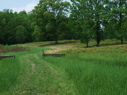
Route 20 north from Charlottesville to Barboursville is an example of an Albemarle County road that faithfully follows its colonial track. For most of its route the modern motor road corresponds very nicely with the old road, often in the old roadbed itself. Scores of old gates blocking the throughway have long since been removed, of course. Where the motor road has wandered off the old path, the old road is often still visible as a set of archaic grassy ruts a few yards away. The principal deviations of that stretch of road are the endpoints. On the Charlottesville end, a stretch of Route 20 has been rationalized for motor traffic. The old road meandered down a hill and then along the Rivanna River. On the Barboursville end, 19th-century railroad construction appears to have caused the main road to shift westward, taking the principal intersection with it and turning the old roadbed into a dead-end lane leading to a railroad embankment. And thus it remains.
US Route 29, the principal north-south arterial highway in Albemarle, corresponds to no one ancestral road. Although it co-opts brief stretches of old road here and there, sometimes for several miles, it does so entirely by happenstance since US 29 was intended from the outset to be a long-distance motor road. Between Charlottesville and Lynchburg, it has distant cousinship with the Lynchburg Stage Road, now called the Old Lynchburg Road, and its alternate, the New Lynchburg Road, whose old course is somewhat hard to define. The principal east-west artery is Interstate 64. I-64 doesn't so much go through Albemarle as past it. When it was built. it seemed a pharaonic architecture whose past was not here but in Thebes and Babylon. With the passage of time I-64 has been broken in, and now seems more patched than grandiose. Between Richmond and Staunton it roughly follows the line of an older highway, US 250, sometimes crossing it but never actually following the older roadbed.
US Route 250 is one of the great primordial east-west arteries of Virginia. This road is a great deal older than the Anglo-African resettlement period. It was a major Native American road connecting several important kingdoms between the Alleghanies and the Tidewater. The earliest English settlers called it the Three Chopt Road. It may well date back to the last Ice Age, but if not, it goes without saying it was there 5,000 years and more ago. In English hands, it began its evolution into US 250. It has wiggled a lot and moved as much as a mile or so in some places but remains today the main street of more than a few towns, including Broad Street in Richmond and Main Street as well as University Avenue in Charlottesville. We can imagine its historical path as a meandering braid, somewhat pinned in place for the present age by cement and asphalt, but maybe as likely as not to resume its self-braiding nature in the fullness of time as this age passes.
When I-64 was constructed, just east of its intersection with US 29 the raised interstate causeway created a wall four lanes wide and 20 feet high. This wall of interstate fell athwart another truly old road, a southern spur off the old Three Chopt Road, which also would have been a crucial inland route for the First Nations. I hardly know what to call this road. Records refer to the northerly part of it as the “upper end of Wheeler Road.” (See page 81 of “Albemarle County Roads 1725-1816” cited above.) It was first mentioned in a petition of 1794 and recognized in 1798. This would have made it eligible for the first time for road orders and manpower requisition for its maintenance. Mason surmises that this road continued south through Arrowhead Valley to intersect with the modern line of US 29 near Red Hill. What records don’t tell or show us is where this road really ran, or what it was really called, or how old it really was. The answer is “very old indeed.”
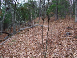
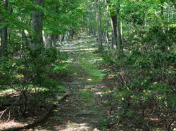
I grew up just off that particular old road. A section of it was part of my paper route. Another section, unmaintained in modern times and left as an archaic mud track, was the usual path my brother and friends and I took to Observatory Hill, where we played and explored incessantly. A third stretch, maintained as a dirt secondary below Stribling Avenue, was our “as far as we would wander” boundary in childhood. The stretch identified in Mason’s study as corresponding to Stadium Road was another neighborhood area where we played as children with a different gang of kids. As kids we saw these areas uncritically, as part of a grid of byways we took for granted. It was years before I realized that the streets and roads on my old paper route were not all of a piece, and that the old road was older than Charlottesville and indeed older than recorded history.
The main clue to where the old road branched off the Three Chopt Road is the geographical feature called Monroe Hill, after James Monroe’s farm, which later became the central grounds of the University of Virginia. If the Old Road went over Monroe Hill to connect to the modern Stadium Road, then the northern end of Alderman Road is the location of its original fork, somewhere near the University Chapel or the Daniel Boone plaque. Alternately, if the Old Road went around the hill, which is also possible, the original fork is the spot where West Main Street changes its name to University Avenue, and the course of the old road is lost under the upper end of Jefferson Park Avenue and joined to modern Stadium Road at the current 3-way intersection beneath the south end of Monroe Hill. Stadium Road then runs to an apparent dead end, beyond which is a dirt trail closed to vehicles that connects to secondary route 782 below Stribling Avenue. Just beyond the railroad overpass, the old road becomes a private lane and tapers out against the wall of the interstate. Beyond the interstate, fragments here and there resume the course toward Arrowhead Valley and Red Hill. Like the Three Chopt, this road may very well be thousands of years old.
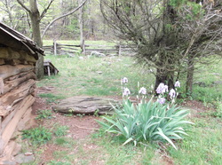
I've long been interested in these bits of old road. Part of the reason is a peculiar thing that happened to me at the age of 17. When I was a teenager the old forestry preserve just west of SR 782 was a great place to go walking with a date. In late April or early May of 1969, the girl I was dating suggested crossing the railroad track to the south to see what was on the other side. This was unknown country to both of us. We crossed the tracks and found an abandoned stone house, which we poked around both inside and out with great interest. Standing in the front yard of this empty structure, I had what I can perhaps best describe as a clear, lucid, and intensely vivid vision of the terrain beyond the place we were standing. The time of day, state of the weather, even the quality of light in my vision matched the present, so at first I thought of it as a moment of clairvoyance. I described this invisible landscape to my companion and she promptly accused me of inventing a hoax in a vain attempt to make myself interesting. Just to see, though, we walked over to look. There was the road, the old drive branching off the road, and the twin stone gateposts I had just described. The odd thing was their age. In my vision, the gateposts had been intact and painted white and the drive between them had been well used. Now the gateposts were crumbling and there was no indication that the drive was being used except by the occasional tractor or hay wagon. The stretch of old road in front of the gateposts, however, was a perfect match. It had fallen out of use before the era of road gravel, and preserved the ruts and dust of the carriage age.
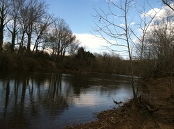
So this was not a vision of the present, but apparently of the past. Its visual aspect and its intensity set it apart from normal memories. And the vision continued for a while. I knew that up this drive there was a substantial wooden bridge next to a cedar tree. What we found, when we walked up the drive, was a pair of planks thrown across Moore's Creek. We saw the rotted stumps of the older bridge I had "remembered," visible in the mud of the creek. The cedar, which I had pictured as a young tree, was thirty feet high and quite massive.
Beyond this point, at the end of the drive, I felt sure we would find a house. I expected it to be a set of foundations only. Vision or memory, however, apparently ended at the bridge. I could not picture the house. As we walked up into the trees on a rutted clay path, I noticed, and I believe my companion on this walk also saw, a pair of peeling clapboard shacks, windowless except for their doors, with muddy yards in front, and black children standing in the two doorways wearing the meanest sort of literal rags, staring at us as if we were some sort of astonishing invaders from another planet. The sheer shock and disbelief on their faces was almost unnerving.
At this point I believe my friend and I both seriously questioned what was happening. Not many dozens of yards farther we ran up against the freshly erected wall of the interstate, under construction, the air beyond yellow with dust and the sound of heavy earthmovers in the distance. We turned and walked back the way we came. I felt I should not look, and I did not look, to see if the shacks and the black children were still there. I would not say I was frightened, but I was dazed somehow. The planks, the muddy remains of rotted bridge posts, the crumbled gate, were as we had seen them a few minutes before.
We walked out along the old road, back to the foot of Stribling Avenue. At one point I said that around the bend, we would see a stone wall on the left. At first it did not seem to be there. Pulling away the honeysuckle vines massed beside the road, I found the wall after all. The idea of the wall was the last element of this experience, and I have to say I did not foresee the wall, but simply knew it was there, which is much closer to how actual mundane memory works.
I've seldom talked about this experience, although I am not shy about odd things in general, and I've never written about it until now. These could have been memories. They would not necessarily have been my own memories. This event also could have been mere clairvoyance, or an act of retrocognition, though the mechanics of such a thing are certainly mysterious to me. People do study this sort of thing. The late Dr. Ian Stevenson, founder of the Division of Perceptual Studies at the University of Virginia, studied such things, and Dr. Jim B. Tucker, also at UVA, studies them now. See:
http://www.medicine.virginia.edu/clinical/departments/psychiatry/sections/cspp/dops/home-page
http://www.medicine.virginia.edu/clinical/departments/psychiatry/sections/cspp/dops/home-page
One thing I could add; when I realized that this vision was not of the present, but of the past, I felt I knew roughly when that past was. Based on the condition of the wood in the creek, it was about a hundred years earlier. I could see that fifty years was no nearly far enough back, and that a hundred and fifty years was plainly much too far. So, I saw the old road in or around 1870, but had the strange experience of seeing it in 1870 from 1969. The shacks and the black children, however, still beg an explanation I can't provide. What did those children see, when they looked at us? Or, to put it another way, when was it, when they saw us?


 RSS Feed